Page 1
Page 2
Page 3
Page 4
Page 5
Page 6
Page 7
Page 8
This information comes from a small, 3.7 x 5.5
inch, 8 page, printed brocure about the park. I found it at the
Archives and Area Research Center of the University of Wisonsin
Parkside campus. Publication date is unknown, but prior to 1924
when it beame a Winnebago
County Forest Preserve.
Its Picturesqueness and Attractiveness as a
Summer Resort
§
Its Interesting History
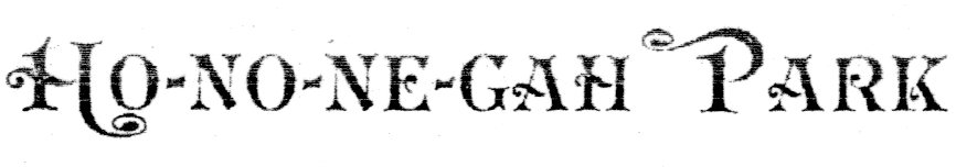
Ho-no-ne-gah Park, situated on Rock river, in Winnebago county, Illinois, has most assuredly a fascinating and instructive history.
The noun Ho-no-ne-gah is a Pottawatomie Indian term, the origin and meaning of which is unknown to the writer. The name does not appear in any glossary or dictionary of the Pottawatomie language thus far published. Ho-no-ne-gah(4) was the Indian wife of Stephen Mack, the first white settler in the valley of Rock river, and beyond peradventure the first white settler in what is now Winnebago county, Illinois.
Mack was a native of Poultney, Rutland county, Vermont. He was born near the close of the 18th century, or a little more than 100 years ago. He received a liberal education, and is said to have attended Dartmouth College for a time. His father, we are informed, occupied a position under the federal government at Detroit, and we know that a brother of Stephen Mack, Merrill E. Mack, afterward his business partner at Macktown, near Rockton, at one time lived in Michigan.(1)
Some years subsequent to the war of 1812, Stephen Mack migrated to the west, by way of the great lakes, landing at Green Bay. He journeyed southward, and about the year 1820, we learn that he was established at Grand Detour, on Rock river, in the business of an Indian trader, selling his furs to John Kenzie at Chicago. At Grand Detour he married Ho-no-ne-gah, a full-blooded Pottawatomie, woman, said to have been the daughter of a chief of that tribe, and by her he became the father of eleven children, nine of whom survived him. Soon atter his marriage, and not later than the year 1822, with his Indian wife, he moved his trading establishment to the mouth of Dry Run, a tributary of Rock river, and running through the upper part of Ho-no-ne-gah Park. The site of his trading post adjacent to the park is to-day plainly visible. At the time mentioned the present park site was occupied by, a village of Winnebago Indians and French half breeds, of whom Chas. Challevaux, Joseph Pelkey and Peter La Vac, and others were well remembered by old settlers of Rockton a few years since, as property owners in the vicinity long prior to the organization of Winnebago county.
At this village Mack continued to live and trade with the Indians until the autumn of 1835, when he moved to the bluff at the mouth of the Pecatonica river at what is now known as Macktown.(2)
Ho-no-ne-gah died at Macktown in 1847, and her husband survived her but three years, dying in April, 1850. Their remains are interred in Phillips' cemetery on the Harrison road(3). At the time of his death he owned upward of 1,000 acres of land near the mouth of the Pecatonica.
On June 26, 1832, Ho-no-ne-gah Park received a visit from the celebrated Sauk Chief, Black Hawk, and a large party of his followers, fresh from their successful encounter with the white militia at Stillman Valley and Elizabeth in Jo Davies county. They effected a crossing of the river from the south at a regular ford leading from the bluff opposite the Park, The aim of Black Hawk was to induce the Winnebagoes at the park to join him in his warlike enterprise against the whites. He seems to have achieved no practical success, although he had in his service a few Winnebagoes. Mack and Hononegah were at the park at the time, and it is said that having had some fear concerning his personal safety, having advised the Winnebagoes against joining the force under Black Hawk, he took refuge on Webber's Island in the river immediately opposite the park, where he remained in hiding for two days, his food being brought to him by the faithful Ho-no-ne-gah.
A few days later, June 30, 1832, Ho-no·ne-gah Park was visited by another delegation of persons of a somewhat different character and personnel, in hot pursuit of Black Hawk, and for whom they were to search in vain for months thereafter. Among this delegation were two subsequent Presidents of the United States: Co1. Zachariah Taylor, and private Abraham Lincoln. Also, Maj. Robert Anderson, who twenty-nine years later surrendered Fort Sumpter. Jefferson Davis, Second Lieutenant, afterwards President of the Confederate States, Albert Sidney Johnson, who thirty years later fell at the battle of Shiloh, Governor Reynolds of Illinois, Sidney Breese, later United States Senator from Illinois, and for many years a judge of the Supreme Court, and Charles Dunn, afterward Chief Justice of Wisconsin Territory; accompanying the above mentioned was a military force of upward of 2,000, militia and regulars. Large crowds of persons have assembled at the park in recent years, but none so large and possessed of the character of that memorable and in many respects distinguished gathering on June 30, 1832.
To those interested in ethnological studies it may be interesting to know that to the thoughtful investigator there is an excellent reason for believing that Ho-ne-ne-gah Park and vicinity has been a gathering place for the red men and the white traders as well. Divers different weapons of warfare, such as stone axes and malls, and mortars and celts, all being articles peculiarly the property of an aboriginal population, have been found there in abundant quantities; also fire arms and weapons more usually in use among the white race have been excavated from the numerous graves and old fire places and primitive bake ovens found in the park and vicinity. In the year 1875 several large sugar maples were felled near the mouth of Dry Run. All of them bore evidence of having been tapped for syrup. The largest tree had more than one hundred sixty-two rings, and was, presumably, more than 162 years old. The tapping was done with a chisel and gouge, and was executed neatly. The hole made by the chisel was of course not visible on the outside of the tree, but by the process of nature had been concealed by the outer growth of bark and body to the extent of one hundred and sixty-two rings, showing pretty conclusively that the white man's chisel had been used 162 years previously at the mouth of Dry Run, or as early as 1713. It would be easy to demonstrate that no Indian in these parts possessed the instruments mentioned at that early day.
The approach of the summer season suggests contemplation as to the best and most healthful mode for the aged and young among us to enjoy such brief hours and days as may from time to time be stolen from the pathways of care, labor and business callings.
What is known as Rock river valley was bountifully favored by nature with exquisite landscapes, oak-openings, and green and fertile bottoms, such as early attracted the attention and employed the pens of Wm. Cullen Bryant, Margaret Fuller, and Bayard Taylor, in vivid descriptions of its charming and practical advantages to early settlers and tourists. But the demands of a large and increasing population have occasioned industrial and agricultural development to materially change the primitive condition and appearance of Rock river valley and Rock river as well.
Fortunately the hand of the despoiler has spared a few, very few, places on the banks of the river, which may stil1 be viewed with the pleasure and delight enjoyed by the explorers and settlers seventy years ago. The writer is intimately acquainted with the scenery on the banks of Rock river from its source to its mouth below Rock Island, and has no hesitancy in making the statement, and challenging its contradiction, that, taking into consideration natural and economical conditions and advantages, Ho-no-ne-gah Park is by far the most beautiful and convenient, the most healthful and cheerful spot in which to spend an hour, a day, a. week, or a summer vacation, that the topography of Rock river valley can supply to the tired and careworn-to the rustic pleasure seeker and to the camper and fisherman.
A succinct statement of the reasons upon which the foregoing conclusion is based may here properly be called for. Ho-no-ne-gah Park is situated less than four miles south of Beloit, Wis., and two miles east of Rockton, Ill., on the left or north bank of Rock river, and consists of twenty-five acres of level bottom land sufficiently shaded by a wealth of venerable oak, beech and sugar-maple trees. The native sod has never been disturbed by the hands of the husbandmen, save in a few places where may still be seen the Indian corn hills, showing the crude efforts of the Winnebagoes to raise corn here 90 years ago.
The trees in the Park are certainly of the finest variety, and the largest size to be seen in Northern Illinois or Southern Wisconsin; and the entire Park is absolutely cleared of underbrush and debris of every character. The grass is mown weekly or oftener. A supply of drive wells on the grounds furnish water of a very superior and hygienic quality to the visitors and campers. Several cottages have-been erected and more are to be erected on the broad and shaded lawn near the river front. Tents and camp sites are furnished to families or individuals at reasonable rates, and a supply of row-boats, including a large gasoline launch, contribute to the pleasure of the fisherman and voyageur for many miles down the river, and above on the Pecatonica and Sugar rivers.
For miles on Rock river above and below Ho-no-ne-gah Park the banks are lined with entangled vines, trees and shrubbery, the foliage is dense and beautifully variegated during the summer and autumn months. Indeed, presumably, the Park and its surroundings must present to the eye of the visitor to-day the same quiet secluded, but primitive and picturesque appearance, that attracted the eyes of Stephen Mack and his Indian wife Ho-no-ne-gah eighty-four years ago.
The accessibility of the Park to the public is a most favorable feature. The Interurban railway line runs passenger cars hourly over its line from Rockford, where it connects with Belvidere and Freeport, to Beloit and Janesville. Forty minutes ride from Janesville, ten minutes ride from Beloit, or thirty minutes ride from Rockford, will land the visitors at the outer entrance. The convenience of access, therefore, affords an opportunity at a small expense for individuals, family gatherings, luncheon or picnic parties to spend a day on the grounds, and to go and return when they choose.
The high moral tone of the place will continue to be maintained in the future as in the past by the proprietor.
Telephone service is supplied the visitor at the park with all towns and cities in the vicinity, and electric light is supplied by the Interurban railway company. This road renders the most excellent service to the public, both as to passenger and light freight traffic, and is by far the best equipped Interurban line in the northwest. All visitors at the Park are assured of receiving the most courteous treatment at the hands of its employees.
For further Information address A. F. GOSS.
Beloit, Wis. Long distance 'phone.
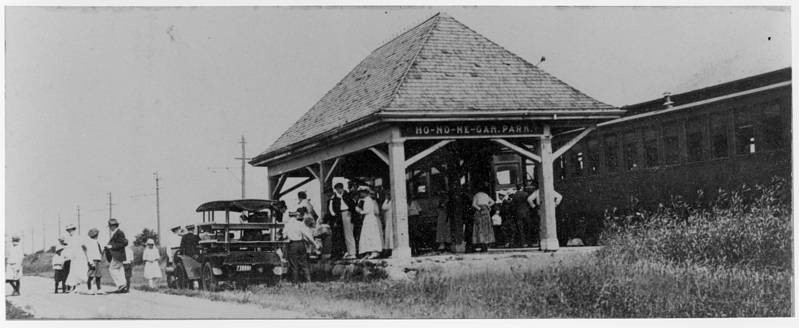
The Rockford and Interurban Railway train stop at Ho-no-ne-gah
Park, near Roscoe, IL, in 1917,
on the day that Barber Colman Company employees and their
families gathered for a company picnic.
The park is now known at Hononegah Forest Preserve
Photograph size: 11 x 24 cm. Donated by Beverly J. Taylor.
Photo property of North
Suburban Library District
Footnotes-
(1) At Stephen Mack's memorial
page Merrill E Mack is said to be a cousin of Stephen
(2) 1835 was the year that Robert J Cross came to Roscoe, he
bought the claim of Mack. Page 353, "History
of Winnebago County, Ill.", H. F. Kett, Chicago, 1877.
(3) Hononegah is now interred at Macktown
Forest Preserve.
(4) Biography of Hononegah at WikiTree
site,
